
The National Hurricane Center keeps a map of how often a hurricane passes within 58 miles of each point on the American coast. Most of the East Coast reads 13, 15, 20 years between storms. Miami reads 6. Cape Hatteras reads 5 — the shortest wait on the entire map, Gulf of Mexico included.
This page is the history behind that number: every storm that mattered here from the one that cut Oregon Inlet in 1846 to the season now under way, what each one actually did to these islands, and the pattern that emerges once you line them up. We make free maps of this coast; nobody paid to be on this page.
Three things the record makes plain
1. The water that does the damage usually comes from behind. On Hatteras Island and Ocracoke the worst flooding in living memory — Emily 1993, Irene 2011, Matthew 2016, Dorian 2019 — came from Pamlico Sound, not the ocean. The ocean side gets the surf and the road damage; the sound side gets the houses.
2. Storms drew the map you are looking at. Oregon Inlet and Hatteras Inlet both opened in one September night in 1846. Storms have cut the island in two in 1933, 1962, 2003 and 2011, and each time the state has had to decide whether to fill the gap or bridge it.
3. Since about 2020 the story has shifted from storms to erosion. The Park Service counts 32 oceanfront houses that have fallen into the sea at Rodanthe and Buxton since 2020, and most of them went in weather that was never a hurricane at all.
Why the Outer Banks get hit so often
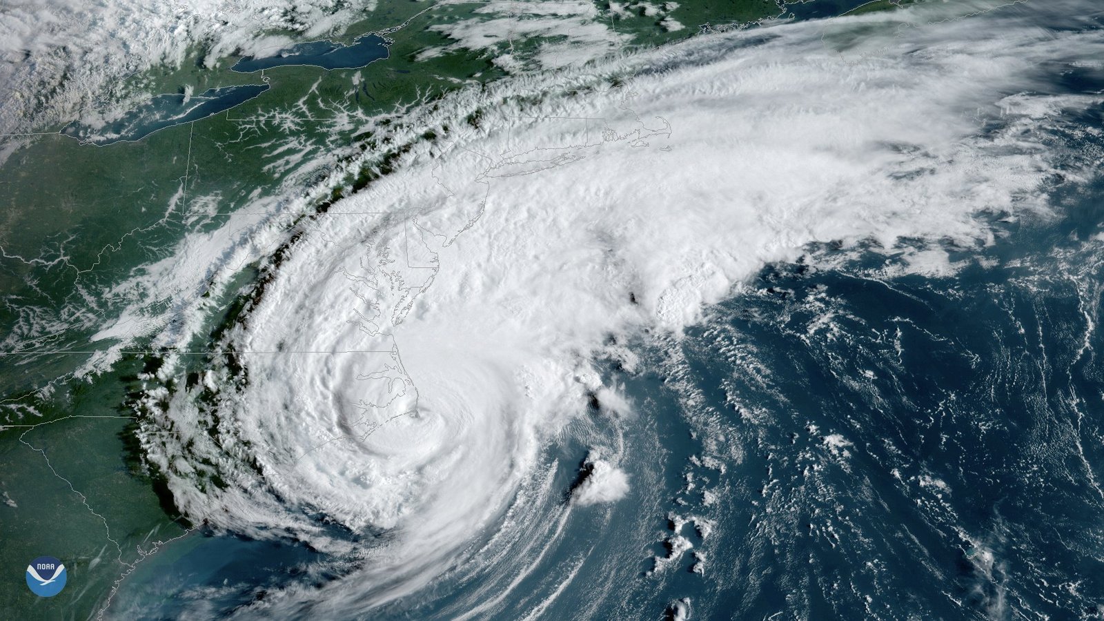
Look at a map of the East Coast and the Outer Banks are the part that sticks out. Cape Hatteras is the elbow of the coast, bent out into the Atlantic toward the warm Gulf Stream, which passes closer to shore here than at any other point north of Florida before it turns away to sea. A hurricane riding up the coast has to get past the cape, and a hurricane that stays comfortably offshore for everybody else can still put its eyewall over Buxton.
The islands themselves make it worse. Most of the Outer Banks stand a few feet above sea level. The highest ground on Hatteras Island is a dune line, and much of that dune line is artificial — built by the Civilian Conservation Corps and the WPA between 1934 and 1941 in what the Park Service records as the North Carolina Beach Erosion Control Project. Behind the islands lie Pamlico, Albemarle and Currituck sounds: more than 2,000 square miles of water in Pamlico Sound alone, most of it under 20 feet deep, with almost no ocean tide to speak of. That shallow water is the key to understanding what storms do here.
A few words, in plain English
Storm surge is ocean water pushed ashore by a storm’s wind, on top of the normal tide. Soundside surge is the same thing happening from the back: the wind piles the sound up against the islands, and when the wind swings round as the storm passes, that water comes across. On the Outer Banks it can rise several feet in an hour. Overwash is ocean water and sand crossing the island in sheets — it is what closes Highway 12. An inlet is a channel cut clean through the island, so the ocean and the sound connect. A nor’easter is a winter or spring storm that is not a hurricane but can do hurricane-scale damage, because it sits for days instead of hours. Landfall is the moment the center of a storm crosses the coast; a storm can wreck the Banks without ever making landfall here, and several have. The category (1 to 5) describes wind only — not rain, not surge, not how long it lasts.
How the sound floods an island
The pattern repeats so often it is worth learning once. As a hurricane approaches from the south, its winds on Hatteras Island blow from the north and east, shoving Pamlico Sound away from the island and piling it up on the mainland side. Hatteras village can be sitting on a sound that has dropped two feet. Then the center passes, the wind swings into the west and southwest, and all that water comes back. The National Weather Service described Emily in 1993 exactly this way: “the persistent northwest winds drove a storm surge from the Pamlico Sound over the island up to 10-1/2 feet in places.” In Dorian, in 2019, the water on Ocracoke rose several feet in a matter of hours once the wind shifted, and people were rescued from their attics by boat. That is the flood that fills houses, and it arrives after everyone thinks the storm has gone by.
If you would rather drive this story than read it, Shifting Sands is a full-day, any-car hunt from our sister site that runs from Jockey’s Ridge to the empty stretch of Buxton beach where the Cape Hatteras Lighthouse stood until 1999, stopping at the places on this page where the sea has already taken the land — Oregon Inlet, Pea Island, Rodanthe, the old lighthouse site. It plays on your phone, at your own pace.
Every storm that shaped the Outer Banks, 1846 to today
The table is the spine of this page. “NHC rating” is the category the National Hurricane Center assigns to the storm’s impact on North Carolina in its official list of U.S. hurricane landfalls; an asterisk means the center never came ashore but hurricane winds did. The wind speeds are what was actually measured on or beside the Outer Banks, not the storm’s peak somewhere out at sea. Storms that passed by with nothing worse than a rough weekend are left out.
| When | Storm | NHC rating in NC | What it did on the Outer Banks |
|---|---|---|---|
| Sept 7–8, 1846 | The 1846 hurricane | Offshore | Sound water burst through the Banks and opened Oregon Inlet and Hatteras Inlet on consecutive nights. Both are still open. |
| Aug 18, 1879 | “Great Beaufort” hurricane | Cat 3 | Anemometers at Hatteras, Kitty Hawk and Portsmouth were destroyed; 100 mph estimated. About 40 dead in North Carolina, mostly around Beaufort. |
| Aug 16–18, 1899 | San Ciriaco | Cat 3 | The strongest landfall in the Outer Banks record. Hatteras Island under 3 to 10 feet of water; 140 mph gusts estimated before the wind instrument failed. Diamond Shoals lightship torn from its mooring. |
| Sept 3, 1913 | 1913 hurricane | Cat 1 | 74 mph at Hatteras; for a time it was feared everyone on Ocracoke had drowned. They had not. |
| Aug 23, 1933 | Chesapeake–Potomac hurricane | Cat 1 | Landfall on the northern Banks near Nags Head; 76 mph at Hatteras; heavy sound flooding in the northeast counties. |
| Sept 15–16, 1933 | 1933 Outer Banks hurricane | Cat 2 | Passed over or just west of Cape Hatteras. 21 dead in North Carolina. Knocked the Bodie Island Coast Guard station off its foundation; Diamond Shoals lightship broke loose again. |
| Sept 18, 1936 | 1936 hurricane | Cat 1 | 80 mph at Hatteras; about 35 feet of beach lost at Nags Head; the road to Norfolk washed out. |
| Sept 14, 1944 | Great Atlantic Hurricane | Cat 2 | Passed just east of Hatteras at 9:20 a.m. Barometer 27.97 inches, the lowest ever read there. Coast Guard cutters Jackson and Bedloe capsized off Oregon Inlet; 47 men lost. |
| Oct 15, 1954 | Hazel | Cat 4 | Came ashore at the South Carolina line, about 200 miles southwest. The Outer Banks caught the edge; the devastation was elsewhere. |
| Sept 19, 1955 | Ione | Cat 2 | Landfall near Morehead City; Pamlico Sound well above normal on the mainland shore. Third hurricane in North Carolina in five weeks, after Connie and Diane. |
| Sept 27, 1958 | Helene | Cat 3* | Eye passed within 10 miles of Cape Fear and then just off Cape Hatteras, at low tide. A near miss that could have been the worst on this list. |
| Sept 11–12, 1960 | Donna | Cat 2 | Crossed eastern North Carolina and left over the northern Banks. Sound flooding along the northern beaches; damage in Manteo and Nags Head. |
| Mar 6–8, 1962 | Ash Wednesday Storm | Nor’easter | Not a hurricane. Five high tides of 30-foot seas. Sixty buildings destroyed and more than 1,200 damaged from Nags Head to Hatteras; cut Buxton Inlet between Avon and Buxton. |
| Sept 30, 1971 | Ginger | Cat 1 | Landfall near Emerald Isle after 27 days at sea. Gusts near 70 mph at Cape Hatteras. |
| Sept 27, 1985 | Gloria | Cat 3 (list) / Cat 2 (winds) | Landfall on Hatteras Island about 1:30 a.m., at low tide. 100 mph sustained at Diamond Shoals; barometer 27.98 inches at Buxton. Far less damage than feared. |
| Aug 17, 1986 | Charley | Cat 1 | Crossed eastern North Carolina; 80 mph gust at Frisco; one drowning near Cape Hatteras. |
| Aug 18–19, 1991 | Bob | Offshore | Passed about 30 miles off Cape Hatteras. 98 mph sustained at Diamond Shoals; Highway 12 closed; one death in North Carolina. |
| Oct 30–Nov 1, 1991 | Halloween nor’easter | Nor’easter | The “Perfect Storm.” Four days of 10-to-12-foot surf; up to four feet of sand on Highway 12; 76 Dare County buildings condemned. |
| Aug 31, 1993 | Emily | Cat 3* | Eye passed just east of the cape. Sound surge 10.2 feet above sea level at Buxton; 553 homes uninhabitable; 147 mph gust at Diamond Shoals. The Hatteras Island benchmark. |
| July 12, 1996 | Bertha | Cat 2 | Landfall near Topsail. 69 mph sustained at Diamond Shoals, 72 mph at the Hatteras ferry office; all of Dare County evacuated. |
| Aug 27, 1998 | Bonnie | Cat 2 | Came ashore at Cape Fear and crossed the northern Banks as it weakened. 76 mph gust at Ocracoke; 6.6 inches of rain there. |
| Aug 30–Sept 4, 1999 | Dennis | Cat 2 offshore, TS landfall | Sat off the coast for days, then came ashore near Harkers Island as a tropical storm. 19 inches of rain at Ocracoke; 98 mph gust at Hatteras village; Highway 12 cut by overwash between Avon and Buxton. |
| Sept 16, 1999 | Floyd | Cat 2 | Landfall at Cape Fear twelve days after Dennis. 79 mph sustained at Duck; 5 to 6 feet of surge in Albemarle Sound flooded Elizabeth City. |
| Sept 18, 2003 | Isabel | Cat 2 | Landfall at Drum Inlet. 101 mph gust at Cape Hatteras. Cut Hatteras Island in two between Frisco and Hatteras village; the village was an island for 65 days. |
| Aug 3, 2004 | Alex | Cat 1* | Center passed about 10 miles southeast of Cape Hatteras; unofficial 105 mph gust in Hatteras village; 6 feet of sound flooding at Buxton and Ocracoke. |
| Sept 14–16, 2005 | Ophelia | Cat 1* | Crawled along the coast for three days; 83 mph gust at Cape Hatteras; 4 to 6 feet in Pamlico Sound. |
| Sept 2–3, 2010 | Earl | Offshore | Passed about 75 miles east of Cape Hatteras as a Category 2. Hatteras Island evacuated; 4.3 feet of surge at Hatteras village. |
| Aug 27, 2011 | Irene | Cat 1 | Landfall near Cape Lookout. Sound surge cut five breaches through Hatteras Island; Highway 12 closed 44 days; 88 mph gust at Hatteras. |
| Oct 28–29, 2012 | Sandy | Offshore | Hundreds of miles out to sea, and still buckled Highway 12 north of Rodanthe and shut it for weeks. Emergency ferry from Stumpy Point. |
| July 3–4, 2014 | Arthur | Cat 2 | Landfall at Shackleford Banks late on July 3, crossed Pamlico Sound and left just north of Oregon Inlet on the Fourth. 99 mph gust at Ocracoke; 5.2 feet of water at Rodanthe. |
| Sept 2–3, 2016 | Hermine | Tropical storm | Lost its tropical character sitting almost on top of Oregon Inlet. 84 mph gust at Duck; Dare County put the damage at $5.4 million. |
| Oct 8–9, 2016 | Matthew | Cat 1* | Never came ashore in North Carolina. Set the record at the Hatteras tide gauge, 5.8 feet above the normal high tide, and topped Isabel in Hatteras village by local accounts. |
| Sept 12–15, 2018 | Florence | Cat 1 | All of Dare County was evacuated; the storm went south. Minimal damage here, catastrophic around Wilmington. |
| Sept 6, 2019 | Dorian | Cat 2 (list) / Cat 1 (winds on land) | Landfall at Cape Hatteras. 101 mph gust at Cape Hatteras; 5 to 7 feet of water in Buxton, Avon, Frisco and Hatteras; 7 feet on Ocracoke, which stayed closed to visitors until December 2. |
| Aug 3–4, 2020 | Isaias | Cat 1 | Landfall at Ocean Isle Beach. 72 mph gust at Avon; 1 to 3 feet of sound flooding. Ocracoke evacuated eleven months after Dorian. |
| Aug 19–22, 2025 | Erin | Offshore | A Category 5 at its peak that passed about 200 miles southeast of the cape. Hatteras Island and Ocracoke evacuated; Highway 12 closed from the Basnight Bridge to Hatteras village; 60 buildings in Buxton damaged. |
| Sept 30–Oct 3, 2025 | Humberto and Imelda swells | Offshore | Neither storm came within warning range. Their combined swell dropped six Buxton houses into the ocean on one afternoon and nine in four days. |
NHC ratings are from the National Hurricane Center’s list of continental U.S. hurricane impacts, 1851–2025; * marks a storm whose center stayed offshore. Wind figures are from NHC storm reports, the Weather Bureau’s Monthly Weather Review, and the National Weather Service office in Newport/Morehead City. Read September 2026.
The storms that drew the map: 1750 to 1899
The oldest storms on the Banks survive as a few lines in a governor’s letter or a ship’s log. The Great Storm of August 18, 1750 wrecked or drove ashore five ships of a Spanish treasure fleet along the North Carolina coast, from Ocracoke to Beaufort, and Governor Dobbs wrote years later that a storm had “carried away Beacon Island” at Ocracoke Inlet. Three centuries on, what happened to everything those ships carried is still the oldest open question on this coast.
The storm that matters most is one almost nobody has heard of. On September 7, 1846, after days of wind from the northeast had piled Pamlico and Albemarle sounds up against the back of the islands, the wind swung into the southwest at about 11 in the morning. The sound came across. The National Weather Service history of North Carolina storms puts it in one sentence: “This created the present Hatteras and Oregon Inlets, the former on the night of September 7th and latter on September 8th.” An islander’s account preserved by the state archives has them watching “the sea and sound connected together and the live oaks washing up by the roots,” and the U.S. Coast Survey sent a man to record it the following year. Oregon Inlet, the channel the Basnight Bridge crosses today, is the scar of that one night. So is Hatteras Inlet, where the Ocracoke ferry runs.
The August 1879 hurricane was the first the new Signal Service weather stations tried to measure, and it broke their instruments: the anemometers at Hatteras, Kitty Hawk, Portsmouth and Fort Macon were all destroyed, with winds estimated at 100 mph or more. That set a pattern. For the next hundred years the strongest storms would be the ones where the instruments quit.
San Ciriaco, August 1899: the strongest landfall in the record
The hurricane that came ashore near the north end of Ocracoke on the evening of August 17, 1899 is still the strongest landfall on the Outer Banks in the National Hurricane Center’s list — a Category 3, 120 mph at the coast, by NHC’s reckoning. The Weather Bureau observer at Hatteras, S. L. Dosher, wrote up what he saw four days later, and his report is the best eyewitness account of any storm on this page. At 1 p.m. on the 17th his instruments read “a velocity of 93 miles with occasional extreme velocities of 120 miles to 140 per hour” — and then the wind record was lost. By 11 a.m. “all the land was covered to a depth of from 3 to ten feet.” There were, he wrote, “not more than four houses on the island in which the tide did not rise.” The Methodist church was wrecked, every bridge was gone, and the office itself flooded 18 inches deep. Nobody died at Hatteras. A pleasure boat was lost at Ocracoke with part of its party.
Offshore the Diamond Shoals lightship left her mooring on the 17th — Dosher wrote that she broke loose; the lighthouse service’s account has her captain slipping the chain — and was driven ashore before dawn on the 18th; her crew was saved by the Creeds Hill lifesavers. Between Salvo and Avon, surfman Rasmus Midgett of the Gull Shoal station went into the surf alone and brought off ten survivors of the barkentine Priscilla, and got the Gold Lifesaving Medal for it. Twenty to twenty-five people died in North Carolina, most of them fishermen caught at sea.
The Weather Bureau years: 1900 to 1949
The Hatteras station, set up in 1874 in the lighthouse keeper’s quarters and moved into a purpose-built two-story office in the village in 1902, gives this period its numbers. The station closed in April 1946; the building still stands, on the National Register.
The 1913 storm blew 74 mph at Hatteras and, according to the Weather Service history, “for a time it was feared that all people on Ocracoke had perished.” The 1924 hurricane partly flooded Ocracoke and drowned two people. Then came 1933, a year with two hurricanes five weeks apart. The first came ashore on the northern Banks near Oregon Inlet on August 23 with 76 mph winds at Hatteras and pushed the tide seven feet above normal at Norfolk. The second, on the morning of September 16, passed over or just west of Cape Hatteras with the barometer at 28.25 inches; the anemometer lost a cup at 76 mph and the Diamond Shoals lightship, torn loose once more, reported winds NHC now estimates at about 120 mph. Twenty-one people died in North Carolina. The Park Service’s own history records that the storm “knocked the Bodie Island Coast Guard Station off its foundation,” that the last residents of Portsmouth village never came back, and that the sea was left “perilously close” to the Cape Hatteras Lighthouse. It also cut a breach between Frisco and Hatteras village — the exact spot Isabel would reopen seventy years later.
The September 1936 storm, 80 mph at Hatteras and rated by the Weather Bureau “one of the most severe of record” there, took about 35 feet of beach at Nags Head. By then the biggest public-works project in the islands’ history was already under way. Beginning in October 1934, the Civilian Conservation Corps and the WPA built the dune line that runs the length of Hatteras Island today: by the Park Service’s count, some 4,126,000 linear feet of sand fence and 283,841,000 square feet of planted grass by 1941, raising a ridge up to 20 feet high from the Virginia line to Ocracoke. Those dunes are why Highway 12 could be built, and why the sound can no longer drain back across the island the way it did in 1846.
The Great Atlantic Hurricane, September 14, 1944
The 1944 storm passed just east of Hatteras at 9:20 in the morning with its barometer at 27.97 inches — the lowest reading ever taken there, then or since — and an estimated 90 mph sustained from the west, with gusts the Weather Bureau put near 110 mph. The Weather Bureau noted that “maximum wind velocities equaled or exceeded all previous records at Hatteras.” Across the Banks 108 buildings were destroyed and about 675 damaged, and one person died in North Carolina.
The deaths were at sea. Two 125-foot Coast Guard cutters, the Jackson and the Bedloe, had gone out to stand by a torpedoed Liberty ship off Cape Hatteras. Both capsized in seas NOAA describes as reaching 50 feet. Of the 41 men aboard the Jackson, 20 survived 58 hours on rafts before a 36-foot launch from the Oregon Inlet station found them; the Bedloe lost 26 of her crew. The Jackson lies in 77 feet of water southeast of Nags Head. Ocracoke reportedly lost ten houses and had some forty fishing boats thrown ashore.
Hazel to Ginger: 1950 to 1979
The famous storm of the era, Hazel on October 15, 1954, is a southern-coast story: a Category 4 that came ashore at the South Carolina line, about 200 miles southwest of Cape Hatteras, and flattened the beaches around Calabash and Long Beach. The Outer Banks got the outer bands. The next summer was the one that hurt here: Connie on August 12, Diane five days later, and Ione on September 19, 1955 — three hurricanes in five weeks, the last two coming ashore around Morehead City. Ione pushed Pamlico Sound well above normal along its mainland shore and did most of its $88 million of damage to farms.
Helene in September 1958 was the near miss of the century. A Category 3 with 135 mph gusts at Wilmington, its eye passed within ten miles of Cape Fear and then ran up the coast just off Cape Hatteras — at low tide. Two years later Donna did come across. After hitting the Florida Keys as a Category 4, Donna made landfall in Onslow County on the night of September 11, 1960, crossed Pamlico Sound and left the state over the northern Banks, with sound flooding along the northern beaches and damage the Weather Service lists in Manteo and Nags Head among other communities.
The Ash Wednesday Storm, March 1962
It was not a hurricane, and it belongs on this page anyway. From March 6 to 8, 1962, a nor’easter parked off the coast through five high tides that happened to fall on some of the highest tides of the year, driving 30-foot seas onto the beach on winds above 70 mph. Sixty buildings on the Outer Banks were destroyed outright and more than 1,200 heavily damaged; people were taken off rooftops in Kitty Hawk and Nags Head; a 501-foot tanker broke in half off Ocracoke. Nobody died on the Banks. The storm cut Buxton Inlet clean through the island between Avon and Buxton. The state threw a wooden bridge across it, a December nor’easter took the bridge out, and by February 1963 the inlet had been dredged shut. Geologists who have studied that stretch note that because it closed so fast only a small shoal built up behind it, so the island there keeps narrowing — which is why Avon-to-Buxton remains one of the most vulnerable miles on Highway 12.
In November 1963 the Herbert C. Bonner Bridge opened across Oregon Inlet: 2.5 miles long, the first bridge Hatteras Island ever had to the rest of the world. It would carry the traffic for 55 years. The 1970s were quiet by local standards; Ginger, which wandered the Atlantic for 27 days before coming ashore near Emerald Isle on September 30, 1971, brought gusts near 70 mph to Cape Hatteras and little else.
Gloria to Floyd: 1980 to 1999
Gloria put its eye ashore on Hatteras Island at about 1:30 in the morning of September 27, 1985. It arrived with a barometer reading of 27.98 inches at Buxton, within a hair of the 1944 record, and 100 mph sustained winds at the Diamond Shoals tower; the National Hurricane Center rates it a Category 3 for North Carolina on the strength of that pressure, though the winds measured on land were Category 2. The reason it is not remembered as a disaster is timing: the Weather Service notes that Gloria “struck at low tide, reducing storm surges to a maximum of 6 feet.” Manteo flooded and Highway 12 was overwashed, but the storm was moving fast and was gone by morning.
Charley the following August crossed the state as a minimal hurricane, gusted 80 mph at Frisco and caused one death in Dare County. Then, on October 26, 1990, the islands were cut off by something that was not weather at all: a runaway dredge, the Northerly Island, hit the Bonner Bridge at 1:28 in the morning and dropped a 370-foot section into Oregon Inlet. For 110 days, until the bridge reopened on February 12, 1991, everything and everyone reached Hatteras Island by ferry — five ferries and a landing craft carried 85,000 vehicles. The emergency ferry route across Pamlico Sound from Stumpy Point to Rodanthe, which the state traces to that winter, is the one that has kept the island supplied in every storm since.
Bob passed about 30 miles off the cape in August 1991 with 98 mph winds at Diamond Shoals and closed Highway 12. The Halloween nor’easter that same fall — the “Perfect Storm” — sent 10-to-12-foot surf onto the beach for four days and eight high tides, buried Highway 12 under as much as four feet of sand in places between Oregon Inlet and Buxton, and left 76 Dare County buildings condemned.
Emily, August 31, 1993: the Hatteras Island benchmark
For anyone who lived on Hatteras Island before 2003, Emily is the storm the others are measured against. Its center never touched land — the eye passed just east of Cape Hatteras on the evening of August 31 — but the eyewall did. The Diamond Shoals tower recorded a sustained 99 mph and a gust of 147 mph, the highest figure on this page. The Weather Service office in Buxton clocked a 98 mph gust before its instrument was disrupted. Then the wind went round to the northwest and Pamlico Sound came over the island: NHC’s report gives “a storm surge flood height of 10.2 feet above sea level at Buxton.” Up to five feet of water stood in houses from Avon through Buxton, Frisco and Hatteras village. Five hundred and fifty-three homes were left uninhabitable, a quarter of the year-round housing in the villages, on damage NHC put at $35 million “mainly on Hatteras Island.” About 160,000 people had been evacuated from the North Carolina barrier islands. Two swimmers died at Nags Head the next day.
1996 to 1999: four hurricanes and a lighthouse on the move
Bertha (July 1996) and Fran (September 1996) both came ashore well to the south, though Bertha put 72 mph winds through the Hatteras ferry office and emptied Dare County. Bonnie in August 1998 came in at Cape Fear and crossed the northern Banks on its way out, gusting 76 mph at Ocracoke with 6.6 inches of rain. Then 1999. Dennis spent the better part of a week wandering off the coast as a Category 2 before finally limping ashore near Harkers Island as a tropical storm on September 4; in that time it dumped 19.13 inches of rain on Ocracoke, gusted 98 mph in Hatteras village, and cut Highway 12 with ocean overwash between Avon and Buxton badly enough that the road was moved — the fourth relocation of that stretch. Twelve days later Floyd made landfall at Cape Fear, sustained 79 mph at Duck with gusts to 98, and pushed five to six feet of water up Albemarle Sound into downtown Elizabeth City, while the inland rivers produced the deadliest flood in the state’s history. Irene passed offshore in October to finish the year.
Between Dennis and Floyd that summer, the Cape Hatteras Lighthouse was already on the move. When it was finished in 1870 the tower stood about 1,500 feet from the surf. By the time it moved the ocean was within a few dozen feet of the base — the Park Service’s own accounts put it anywhere from 15 to 120 feet, depending on the year and the storm. Beginning June 17, 1999, engineers rolled the 4,830-ton lighthouse 2,900 feet inland over 23 days and set it down on July 9, about 1,600 feet from the ocean. The move was a response to a century of storms like the ones above, and it was finished weeks before Dennis arrived.
Isabel to Dorian: 2000 to 2019
Isabel, September 18, 2003: the island cut in two
Isabel came ashore near Drum Inlet on Core Banks at about 1 p.m. as a Category 2, 105 mph, and drove its right-hand side across Hatteras Island. The Cape Hatteras tower measured 81 mph sustained with a gust of 101; an unofficial gauge at Kitty Hawk read 117 mph. The surge on the ocean side ran 6 to 8 feet, with 15-to-25-foot waves on top of it, and a tide gauge on the Cape Hatteras pier read 7.7 feet before the pier was destroyed. Three houses in Hatteras village were washed into the sea.
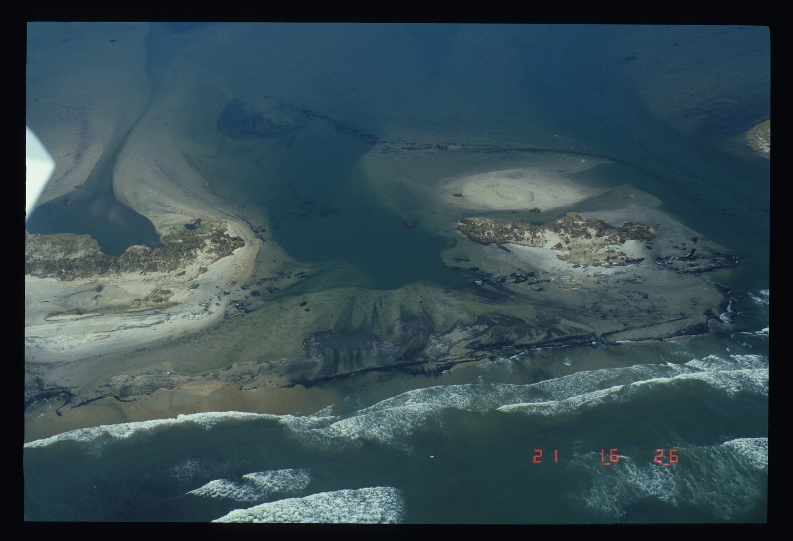
What Isabel is remembered for happened between Frisco and Hatteras village. The ocean broke through the island and met the sound, opening what everyone immediately called Isabel Inlet: roughly 1,700 to 2,000 feet wide, split by two sandbars into three channels, the main one more than 15 feet deep. Highway 12 simply ended at the water. Hatteras village became an island. Schoolchildren went to Buxton by boat, groceries came by ferry, and the Ocracoke ferry stopped running. The Army Corps of Engineers hired a hopper dredge to pump the inlet full of sand from the Hatteras Inlet channel; the state repaved the road across it; and on November 22, 2003, 65 days after the storm, Highway 12 reopened. Isabel did about $170 million in insured damage in North Carolina and killed one person directly in the state.
2004 to 2010: the near misses
Alex (August 3, 2004) put its center about 10 miles southeast of Cape Hatteras as a Category 2 and gave Hatteras village an unofficial 105 mph gust; six feet of sound water went through Buxton and Ocracoke village, flooding hundreds of cars — the worst Ocracoke had seen since Gloria. Ophelia spent September 14 to 16, 2005 crawling along the coast at walking pace, with an 83 mph gust at Cape Hatteras. Earl passed 75 miles off the cape as a weakening Category 2 on September 3, 2010 and emptied Hatteras Island for a storm that in the end delivered 4.3 feet of surge and about half a million dollars of damage. Every one of these produced an evacuation.
Irene, August 27, 2011: the sound comes through
Irene made landfall near Cape Lookout at 8 a.m. as a Category 1, 85 mph, and passed over the sounds. The gusts were respectable — 88 mph at Hatteras, 85 at Duck — but Irene’s damage came from the water. NHC’s report describes “a storm surge of 8 to 11 ft” in the western part of Pamlico Sound, and when the wind swung, roughly six feet of that surge crossed the northern half of Hatteras Island from the back. It cut five breaches between Oregon Inlet and Cape Hatteras, in two clusters: one at the Rodanthe S-curves, and one through Pea Island near the old Pea Island station, where the state’s engineers logged “200+ lf of open breach 6 to 12 ft. deep.” That second cut was at New Inlet, a spot the Park Service notes had opened and closed repeatedly between the 1600s and 1945. An old inlet had simply reasserted itself.
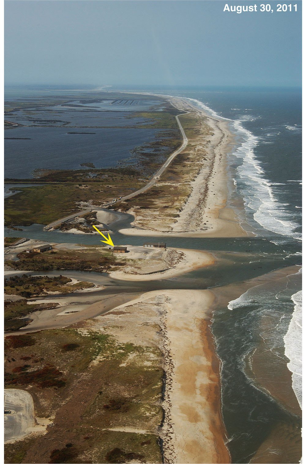
Hatteras Island was cut off for 44 days. The Stumpy Point–Rodanthe emergency ferry carried everything, and a temporary steel bridge went over the Pea Island breach in time for the road to reopen on October 10. Dare County put the damage at just under $54 million. The permanent fix, the 2,350-foot Captain Richard Etheridge Bridge, opened to traffic in November 2017 and was dedicated in February 2018, named for the keeper of the Pea Island station, the first Black man to command a lifesaving station in the United States.
2012 to 2018: Sandy, Arthur, Matthew, and a cut cable
Sandy in October 2012 stayed hundreds of miles out to sea and still put five feet of sound water from Rodanthe to Hatteras and buckled Highway 12 at the S-curves badly enough to close it for weeks and bring the emergency ferry back. Arthur came ashore at Shackleford Banks at 11:15 p.m. on July 3, 2014 as a Category 2, the earliest hurricane in the state’s record, crossed Pamlico Sound overnight and left just north of Oregon Inlet before dawn on the Fourth of July; it gusted 99 mph at Ocracoke, put 5.2 feet of water on the ground in Rodanthe and buckled Highway 12 by the Pea Island bridge, and Hatteras Island was evacuated for the holiday.
Hermine lost its tropical character sitting practically on Oregon Inlet on September 3, 2016, gusting 84 mph at Duck. Five weeks later Matthew ran up the coast just offshore on October 8 and 9 and set the record at the Hatteras tide gauge: 5.8 feet above the normal high-tide line, which the Weather Service called “record storm surge levels.” Frisco had five feet of water on Highway 12; a 94 mph gust hit Jennette’s Pier; Kill Devil Hills recorded more than 12 inches of rain. Hatteras village residents said it beat Isabel and Emily.
The most expensive week of 2017 had nothing to do with wind. On July 27 a construction crew building the new Oregon Inlet bridge drove a steel casing through the three underground cables that carry all of Hatteras Island’s and Ocracoke’s electricity. Both islands were ordered evacuated of visitors — about 10,000 from Ocracoke and thousands more from Hatteras Island — and stayed dark for a week until the power was reconnected on August 3. Maria in September 2017 passed 150 miles out to sea and still emptied Hatteras Island. Florence in September 2018 prompted a mandatory evacuation of all of Dare County and then went to Wilmington instead. The remains of Michael gusted 74 mph on Hatteras Island in October 2018 and put two to four feet of sound water across the northern villages.
Dorian, September 6, 2019: Ocracoke’s storm
On February 25, 2019, the 2.8-mile Marc Basnight Bridge opened across Oregon Inlet, built for a hundred years, and the old Bonner Bridge closed. Six months later the newest bridge on the coast got its first hurricane. Dorian, which had been a Category 5 over the Bahamas, made landfall at Cape Hatteras at about 8:30 on the morning of September 6, 2019 with an intensity NHC puts at 100 mph; its report adds that those Category 2 winds “occurred mostly over water in the eastern semicircle” and that the island itself saw Category 1 conditions. Hatteras High School recorded a 101 mph gust, the Oregon Inlet Coast Guard station 99. Five to seven feet of water went through Buxton, Avon, Frisco and Hatteras village.
Ocracoke got it worse than anyone could remember. As the wind shifted behind the eye, Pamlico Sound rose about seven feet above the ground across the village in a couple of hours; the Park Service reported “up to 7 feet of water above the ground in many residential and park areas,” more than 400 homes and buildings flooded, well over a hundred vehicles drowned in the park’s own lot, and people pulled from their attics by boat. Two 500-foot sections of Highway 12 near the north-end ferry dock were destroyed. The island stayed closed to visitors until December 2, 2019. Dare County tallied $14.8 million of damage across 1,126 structures from Duck to Hatteras.
Since 2020: fewer landfalls, more of the island in the sea
Isaias came ashore at Ocean Isle Beach on the night of August 3, 2020 as a Category 1, gusted 72 mph at Avon and put one to three feet of sound water on the Banks; Ocracoke, still rebuilding, was evacuated eleven months after Dorian. That is the last hurricane landfall in North Carolina. Since then the pattern has changed. The storms that have hurt the Outer Banks in the 2020s have mostly been nor’easters and the swell from hurricanes far out at sea, arriving on a beach that no longer has room to absorb them.
The November 2021 nor’easter pushed the Duck gauge to 6.87 feet, the fourth-highest reading in that station’s history and the second-highest from anything that was not a tropical storm; Highway 12 closed for three days. Ophelia came ashore at Emerald Isle as a tropical storm on September 23, 2023 and put one to three feet of sound water from Ocracoke to Duck. In September 2024 a system that never quite became a storm, Potential Tropical Cyclone Eight, dropped 10.34 inches of rain at Frisco and closed the north end of Ocracoke under a mile of ponded water.
In July 2022 the 2.4-mile Rodanthe “Jug Handle” Bridge opened, swinging Highway 12 out over Pamlico Sound to bypass the S-curves at Mirlo Beach — the stretch Irene and Sandy had broken. It was the third new bridge on Highway 12 in five years, each one built because of what a storm on this page had done.
Erin, August 2025: a Category 5 that never came near
Erin peaked at 160 mph, a Category 5, on August 16, 2025, and at its closest passed about 200 miles southeast of Cape Hatteras early on August 21 as a 105 mph Category 2. That was close enough. With tropical storm warnings up from Beaufort Inlet to Duck and the county warning of “large breaking waves of 15-20-plus feet” in the surf zone, Dare County declared a state of emergency at 6 p.m. on Sunday, August 17 and ordered Hatteras Island (Zone A) evacuated: visitors from 10 a.m. Monday, residents from 8 a.m. Tuesday. Hyde County did the same for Ocracoke. For the better part of a week the ocean went across Highway 12, which was closed from the Basnight Bridge all the way to Hatteras village. NHC’s report puts the water at Duck 3.4 feet above the normal high tide and the damage in North Carolina at about $3.1 million; Dare County’s first count was 56 houses and four businesses damaged in Buxton and 19 houses in Rodanthe. Two structures in Buxton were badly damaged, but no house fell. Ocracoke was reachable only by the mainland ferries for days afterward.
The house collapses: 32 since 2020, and counting
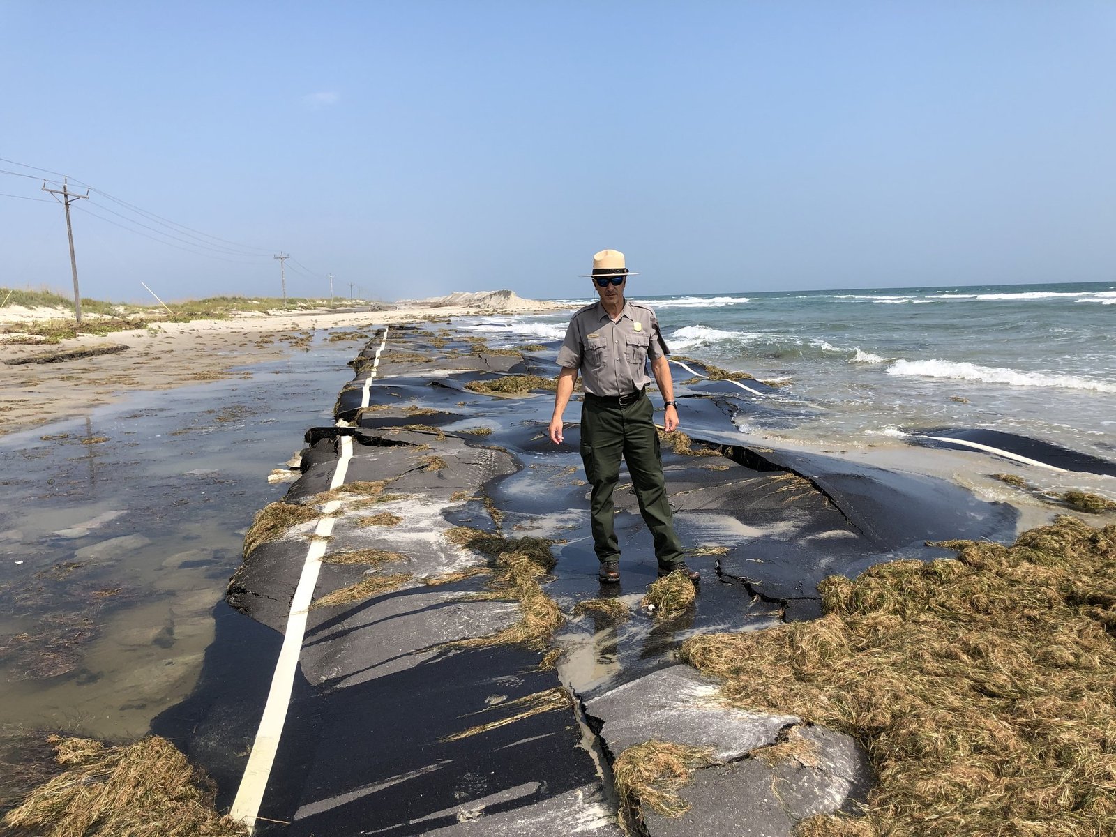
The Park Service keeps the tally, and it is the clearest measure of what has changed on this coast. Between May 2020 and June 2026, 32 privately owned oceanfront houses collapsed onto the beaches of Cape Hatteras National Seashore, every one of them unoccupied at the time, without a single injury. The first eleven were all in Rodanthe. Then the beach at Buxton, north of the lighthouse, gave way.
On the afternoon of September 30, 2025, with Hurricane Humberto and Hurricane Imelda both far out at sea and no watch or warning posted for the North Carolina coast, five Buxton houses on Cottage Avenue and Tower Circle Road fell between 2:00 and 2:45 p.m., and a sixth went at 11 that night. NHC’s report on Imelda records that “large swells from both Imelda and distant Hurricane Humberto caused an extended period of rough surf and damaging waves.” Three more went over the next three days, one of them back in Rodanthe. A plain nor’easter took five more Buxton houses on October 28, and four went in a winter storm on February 1 and 2, 2026. In late 2023 the Park Service bought two threatened houses on East Beacon Drive in Rodanthe and took them down before the ocean could.
| Year | Houses lost | Where | What was happening |
|---|---|---|---|
| 2020 | 1 | Rodanthe | Overnight, May 29 |
| 2022 | 3 | Rodanthe | One on “a calm winter day” in February; two in a multi-day May nor’easter |
| 2023 | 1 | Rodanthe | March, in rough weather |
| 2024 | 6 | Rodanthe | Swell from Hurricane Ernesto in August; three in the week after Potential Tropical Cyclone Eight in September; one in November |
| 2025 | 16 | 15 Buxton, 1 Rodanthe | One on September 16; six on September 30 alone in the Humberto–Imelda swell and nine in four days; one more on October 18; five in an October 28 nor’easter |
| 2026 (to date) | 5 | Buxton | Four in a winter storm February 1–2; one on June 2 |
National Park Service structure-collapse timeline for Cape Hatteras National Seashore, read September 5, 2026; storm attributions from NHC and NWS reports where the Park Service does not name one.
The 2026 season so far
Checked on September 5, 2026, at the statistical peak of the season: five named storms so far this year — Arthur, Bertha, Cristobal, Dolly and Edouard — none of them a hurricane and none of them anywhere near the Outer Banks. The National Hurricane Center’s outlook this week shows nothing forming in the Atlantic. Twelve weeks of the season remain. For what to watch and how the evacuation orders work if something does come, see the Outer Banks hurricane guide.
The inlets storms have cut
Barrier islands are supposed to do this. Geologists count dozens of inlets that have opened and closed along the Outer Banks since the first maps were drawn; the names on old charts — Roanoke Inlet, Caffeys Inlet, Gunt Inlet, New Inlet — are mostly places where the road now runs. These are the ones a storm opened within the historical record.
| Inlet | Opened | What happened to it |
|---|---|---|
| Oregon Inlet | September 7–8, 1846 hurricane | Still open, and moving south. Named for the steamer Oregon, said to have been the first vessel through. Bridged 1963 (Bonner) and 2019 (Basnight). |
| Hatteras Inlet | September 7, 1846 hurricane, the night before Oregon Inlet | Still open. The Hatteras–Ocracoke ferry crosses it. |
| New Inlet (Pea Island) | Open on and off from the 1600s; open in the 1930s and bridged by the state; closed by 1945; reopened by Irene, August 27, 2011 | Bridged again in 2017 by the 2,350-foot Captain Richard Etheridge Bridge. |
| Breach between Frisco and Hatteras village | September 1933 hurricane | Closed; reopened at the same spot by Isabel in 2003. |
| Buxton Inlet | Ash Wednesday nor’easter, March 1962 | A wooden bridge lasted until a December nor’easter; dredged shut by February 1963. |
| Isabel Inlet | September 18, 2003 | About 1,700 to 2,000 feet wide in three channels. Filled by an Army Corps dredge; Highway 12 reopened November 22, 2003. |
| Irene breaches at the Rodanthe S-curves | August 27, 2011 | Filled and repaved within weeks; the road there was later bypassed by the 2022 Jug Handle Bridge. |
Sources: NWS history of North Carolina tropical cyclones (1846), East Carolina University and the NPS geologic inventory (New Inlet, Buxton Inlet, Isabel Inlet), NCDOT Division 1 (Irene breaches).
The road is the story now
Everything south of Oregon Inlet depends on one two-lane highway and one bridge, and every storm on this page since 1963 has really been a story about whether Highway 12 stayed open. The state’s own engineers list seven “hot spots,” at some of which the road runs within 150 feet of the ocean at high tide: the Canal Zone just south of the Basnight Bridge, the Pea Island visitor center, the Rodanthe S-curves, Avon, the north end of Buxton by the old Cape Hatteras Motel, the Frisco–Hatteras village stretch where Isabel Inlet opened, and the first three miles of Ocracoke south of the ferry dock. If you compare that list with the table above you will notice it is the same list.
The response has been to build bridges and move the road: the Basnight Bridge (2019) over Oregon Inlet, the Etheridge Bridge (2017) over the Irene breach, the Jug Handle Bridge (2022) around the S-curves, and a decades-long argument about what to do with the rest. When the road does go, the state runs the emergency ferry from Stumpy Point on the mainland to Rodanthe, first used after the 1990 dredge accident and heavily after Irene and Sandy. Ocracoke, with no road link at all, falls back on its Swan Quarter and Cedar Island ferries — a two-and-a-half-hour crossing — whenever the Hatteras ferry or the north-end road is out, as it was for weeks after Dorian and days after Erin.
For what all of this means when you are driving in, the evacuation routes page has the live road map, and the beach access conditions page is rebuilt every morning from the Park Service’s ramp reports.
Outer Banks storm records
| Record | Holder | Detail |
|---|---|---|
| Strongest hurricane to come ashore | San Ciriaco, August 17, 1899 | Category 3, about 120 mph at the coast — the highest wind the National Hurricane Center assigns to any landfall on the Banks |
| Highest wind measured | Emily, August 31, 1993 | 147 mph gust at the Diamond Shoals tower; 99 mph sustained. On land: 117 mph unofficial gust at Kitty Hawk in Isabel, 101 mph at Hatteras High in Dorian |
| Lowest barometer at Hatteras | Great Atlantic Hurricane, September 14, 1944 | 27.97 inches of mercury (947.2 millibars); Gloria read 27.98 at Buxton in 1985 |
| Deepest flooding on Hatteras Island | Emily, 1993 | 10.2 feet above sea level at Buxton, from the sound |
| Worst flooding on Ocracoke in living memory | Dorian, September 6, 2019 | About 7 feet above the ground across the village by the Park Service’s account; more than 400 homes and buildings flooded |
| Highest reading at the Hatteras tide gauge | Matthew, October 9, 2016 | 5.8 feet above the normal high-tide line, called a record by the Weather Service |
| Longest a village has been cut off | Isabel, 2003 | Hatteras village, 65 days, until Highway 12 reopened November 22; Irene closed the road for 44 days in 2011; the 1990 dredge accident closed the Bonner Bridge for 110 days |
| Earliest hurricane | Arthur, July 3–4, 2014 | The earliest hurricane landfall in North Carolina’s record, by Dare County’s reckoning |
| Most houses lost in a day | September 30, 2025 | Six in Buxton, from the swell of two hurricanes hundreds of miles away |
| Most recent landfall on the Banks | Dorian, September 6, 2019 | At Cape Hatteras. Isaias in 2020 is the most recent hurricane landfall anywhere in North Carolina |
| Return period at Cape Hatteras | National Hurricane Center | A hurricane within 58 miles about every 5 years; a major hurricane about every 16 |
All figures are from the sources named in the box at the bottom of this page. “Above sea level” and “above the normal high-tide line” are different measuring sticks and are not directly comparable.
What this means for a vacation week
Less than it sounds. The return period is five years, not five weeks; the season runs June 1 to November 30 with its peak on September 10, and the great majority of weeks inside it pass with nothing but a good swell. What the history does tell you is how it goes when something comes: Hatteras Island and Ocracoke are ordered out first and often alone, the northern beaches are usually last or not at all, the road south of Oregon Inlet is the first thing to close and the last to reopen, and the water that matters is behind you, not in front. The hurricane guide explains how the orders and the re-entry stages work; the weather page and the webcams will show you what the beach looks like right now.
Outer Banks hurricane history: questions people ask
When was the last hurricane to hit the Outer Banks?
Hurricane Dorian made landfall at Cape Hatteras on the morning of September 6, 2019, the most recent landfall on the Outer Banks themselves; it put five to seven feet of water through the Hatteras Island villages and about seven feet across Ocracoke. Isaias in August 2020 was the last hurricane to make landfall anywhere in North Carolina. Hurricane Erin in August 2025 never came within 200 miles but still forced the evacuation of Hatteras Island and Ocracoke and closed Highway 12 for days.
What was the worst hurricane in Outer Banks history?
It depends what you measure. For wind, the August 1899 San Ciriaco hurricane, the strongest landfall on the Banks in the National Hurricane Center list, with gusts estimated at 140 mph before the instrument failed and the whole of Hatteras Island under 3 to 10 feet of water. For flooding on Hatteras Island, Emily in 1993, with 10.2 feet of sound water at Buxton and 553 homes uninhabitable. For Ocracoke, Dorian in 2019. For changing the map, Isabel in 2003, which cut the island in two, and the 1846 storm that opened Oregon and Hatteras inlets.
How often do hurricanes hit the Outer Banks?
The National Hurricane Center’s return-period map puts a hurricane within 58 miles of Cape Hatteras about once every 5 years and a major hurricane (Category 3 or stronger) about once every 16 years. Five years is the shortest interval anywhere on the U.S. coast. Storms whose centers actually crossed the Banks at hurricane strength are rarer than that — in the past forty years Gloria in 1985, Arthur in 2014 and Dorian in 2019 are the ones that come to mind — but many more have done serious damage from offshore or by crossing the sounds.
Has a hurricane ever cut Hatteras Island in two?
Several times. The September 1846 hurricane opened both Oregon Inlet and Hatteras Inlet, which are still there. A 1933 hurricane breached the island between Frisco and Hatteras village; the Ash Wednesday nor’easter of 1962 cut Buxton Inlet between Avon and Buxton; Isabel reopened the Frisco cut in 2003 as the 2,000-foot Isabel Inlet, which took two months to fill; and Irene in 2011 cut five breaches, including one at New Inlet on Pea Island that is now crossed by the Etheridge Bridge.
Why does Ocracoke flood from the sound instead of the ocean?
Because Pamlico Sound is huge, shallow and has almost no tide, so wind moves it more than the moon does. As a hurricane approaches, north and east winds push the sound away from the islands and pile it against the mainland. When the storm passes and the wind swings to the west and southwest, that water comes back across in a matter of hours. In Dorian in 2019 the Park Service measured up to seven feet of water above the ground on Ocracoke, and people were taken out of their attics by boat. Ocracoke village sits on the sound side, at the receiving end.
Did Hurricane Helene hit the Outer Banks?
No. Helene in September 2024 came ashore in Florida and did its damage in the mountains of western North Carolina, some 400 miles from the coast. The Outer Banks were not affected. The Helene that did pass the Outer Banks was a different storm in September 1958, a Category 3 that ran just offshore at low tide.
Has a hurricane hit the Outer Banks in 2026?
Not as of September 5, 2026. The season has produced five named storms so far, none of which reached hurricane strength or came near North Carolina, and the National Hurricane Center currently shows nothing developing in the Atlantic. The five houses that fell into the sea at Buxton this year went in a winter storm in February and a coastal storm in early June, not in a hurricane. We will update this page if that changes.
Checked against the sources
Categories and landfall figures are from the National Hurricane Center’s list of continental U.S. hurricane impacts, 1851–2025, and from NHC’s tropical cyclone reports for each storm since 1995 (Emily, Dennis, Floyd, Isabel, Alex, Ophelia, Earl, Irene, Sandy, Arthur, Hermine, Matthew, Florence, Dorian, Isaias, Ophelia 2023, Potential Tropical Cyclone Eight, Erin, Humberto and Imelda). The return periods are read off NHC’s return-period maps. Storms before 1950 are from the NOAA/NWS history Tropical Cyclones Affecting North Carolina Since 1586, the Weather Bureau’s Monthly Weather Review for 1899, 1933, 1936 and 1944, NHC’s hurricane re-analysis notes, and the Park Service’s study of the Hatteras Weather Bureau station, which reproduces S. L. Dosher’s 1899 report in full.
Local wind, surge and damage figures are from the National Weather Service office in Newport/Morehead City (event pages for Gloria, Emily, Irene, Sandy, Matthew, Michael, Dorian, Isaias, the November 2021 nor’easter, Potential Tropical Cyclone Eight and Erin), Dare County Emergency Management’s hurricane history and its August 2025 bulletins, the National Park Service (Dorian damage, the Ocracoke reopening, the structure-collapse timeline read September 5, 2026), the U.S. Geological Survey (Irene breach survey), the Army Corps of Engineers and NCDOT Division 1 (breach dimensions, Highway 12 hot spots, the emergency ferry), and NOAA’s Monitor sanctuary record of the cutter Jackson. The 1962 and 1990 accounts, the Isabel Inlet dimensions and the reopening dates lean on Coastal Review, the Island Free Press and the Outer Banks Voice, checked against the official figures where both exist.
Where sources disagree we say so or pick the official one: NHC lists Dorian’s landfall intensity as Category 2 but states the island saw Category 1 winds; NHC rates Gloria a Category 3 on pressure while the measured winds were Category 2; Isabel Inlet’s width is given as 1,640 to 2,000 feet depending on the day it was measured. Categories for storms before 1990 have been revised by NHC’s re-analysis, and the older books often give a higher number than the one used here. Photos are U.S. government work: NOAA (Dorian satellite), the U.S. Geological Survey (Isabel Inlet, Irene breach) and the National Park Service (Ocracoke).
What we sell: nothing on this page. No affiliate links, no paid placement. This is history, not a forecast — for anything live, use the National Hurricane Center and Dare County Emergency Management. Last checked: September 2026.