
Corolla · Nags Head · Hatteras · Ocracoke
The mile markers, drawn
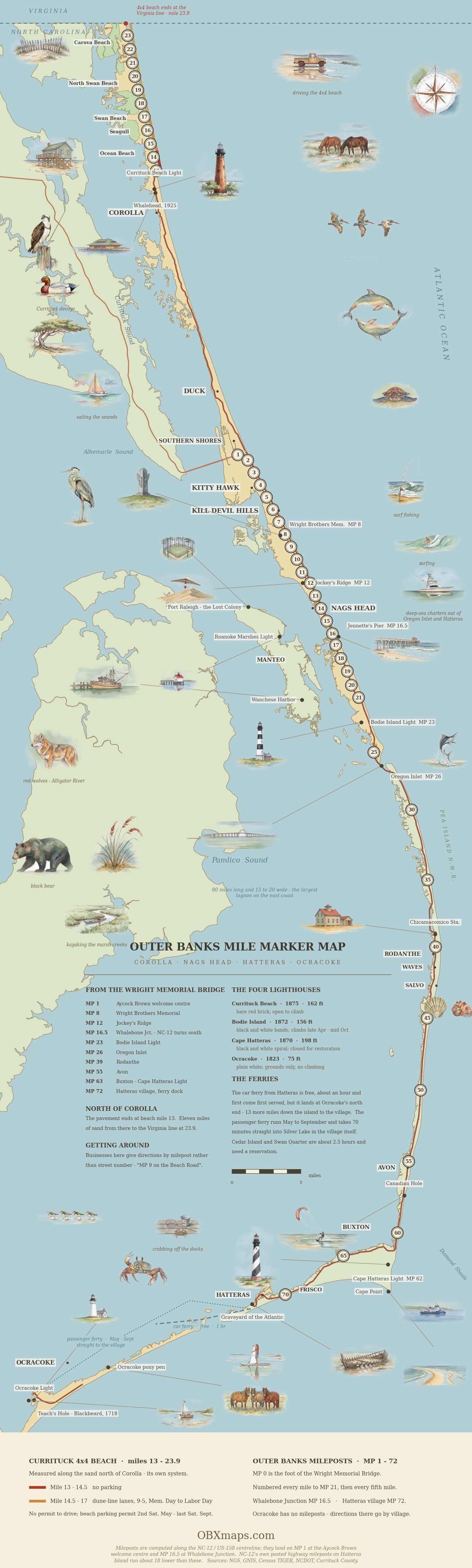
The whole system on one sheet — Currituck’s beach miles in the north, the mileposts from the Wright Memorial Bridge south to Whalebone, and NC-12 carrying the numbering down Hatteras Island.
Highway 12 mile markers are the simplest way to find your place on the Outer Banks. NC Highway 12 is the spine of the Outer Banks: 148 miles from Sea Level on the mainland up to just north of Corolla, broken by two ferry crossings. The Outer Banks National Scenic Byway follows it past 21 coastal villages.
Making a day of the drive? That same road south — Jockey’s Ridge down to the Cape Hatteras Lighthouse — is the route of Shifting Sands, a self-guided investigation you play on your phone about the villages, inlets and lighthouses the sand has moved out from under.
Because the villages blur together and street signs are sparse, locals and businesses give directions by milepost rather than address, so a rental listed near MP 9 or a restaurant at MP 13 tells you exactly how far north or south it sits. Learning to read the markers turns a confusing stretch of two-lane highway into a simple number line, and it makes planning beach days, dinner reservations, and grocery runs far easier once you arrive.
Mileposts are how the Outer Banks gives directions. The convention visitors actually use runs along US 158 and the Beach Road from MP 1 in Kitty Hawk down to about MP 16.5 at Whalebone Junction in Nags Head — that is the stretch where a business will tell you it is “at MP 9” or “near MP 13.” NC Highway 12 itself carries green highway mile markers that keep counting south down Hatteras Island to Hatteras Village, so you will see higher numbers on the road (MP 23 at Bodie Island Lighthouse, around MP 72 in Hatteras Village). Duck uses street names instead, and the villages on Hatteras Island and Ocracoke mostly give directions by village name rather than milepost.
Milepost Quick Reference
The numbers start at MP 1 just past the Wright Memorial Bridge in Kitty Hawk and climb as you drive south. Mileposts are the same on the Beach Road and the Bypass — MP 12 is MP 12 on either — so the number gets you to the right stretch of town; the road name tells you which of the two parallel roads you want.
| Milepost | What’s there | Town |
|---|---|---|
| MP 1 | Aycock Brown Welcome Center (Bypass) | Kitty Hawk |
| MP 4.5 | Kitty Hawk beach-road strip | Kitty Hawk |
| MP 6 | Avalon Fishing Pier | Kill Devil Hills |
| MP 7.5–8 | Wright Brothers National Memorial | Kill Devil Hills |
| MP 9 | Central Kill Devil Hills (Bypass) | Kill Devil Hills |
| MP 11.5 | Nags Head Fishing Pier | Nags Head |
| MP 12 | Jockey’s Ridge State Park | Nags Head |
| MP 16.5 | Whalebone Junction — US 64, US 158 and NC 12 meet; end of the main drag | Nags Head |
| MP 16.5 | Jennette’s Pier | Nags Head |
| MP 23 | Bodie Island Lighthouse | South of Nags Head |
| ~MP 72 | Hatteras Village — the NC 12 mileposts keep counting down Hatteras Island, but most businesses there give directions by village name instead | Hatteras Island |
Corolla & Carova
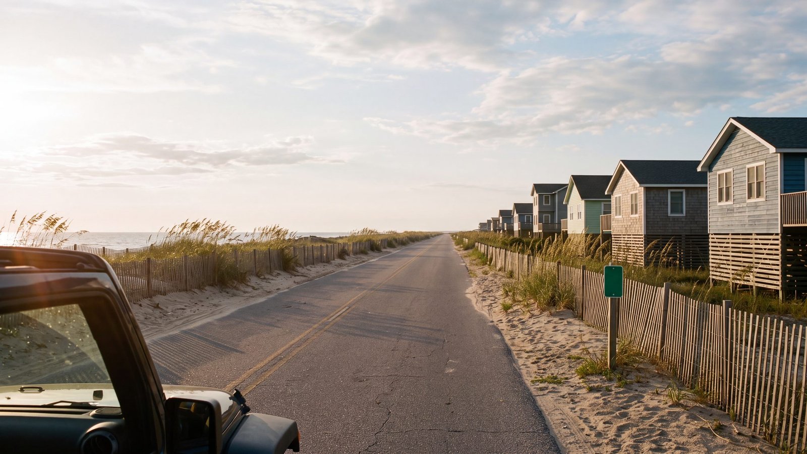
No NC 12 mileposts in Corolla — Corolla gives directions by landmark; north of where the pavement ends, beach mileposts mark distances in 4x4 territory.
- Currituck Beach Lighthouse (Historic Park)
- Whalehead Club (Historic Mansion)
- Corolla Wild Horse Museum
- Wild Horse Territory (Carova Beach)
Duck
No Milepost System — Duck uses street names rather than mileposts. The village center is the main reference point.
- Duck Town Boardwalk (Village Center)
- Duck Research Pier
- Waterfront Shops & Restaurants
Southern Shores through Nags Head
MP 1 – MP 17+ — The traditional milepost system begins at MP 1 in Kitty Hawk, just past the Wright Memorial Bridge, and runs south through Nags Head.
- Wright Brothers National Memorial (MP 7.5)
- Jockey’s Ridge State Park (MP 12)
- Jennette’s Pier (MP 16.5)
- Avalon Pier (MP 6)
- Nags Head Pier (MP 11.5)
For a town-level breakdown of what sits at each of these markers, see our Nags Head milepost guide.
Hatteras Island
Pea Island through Hatteras Village — Hatteras Island stretches from Pea Island National Wildlife Refuge to Hatteras Village ferry terminal.
- Pea Island National Wildlife Refuge (MP 26-39)
- Chicamacomico Life-Saving Station (Rodanthe)
- Captain Richard Etheridge Bridge, the Rodanthe “jug handle” that bypasses the old S-curves
- Cape Hatteras Lighthouse (Buxton)
- Graveyard of the Atlantic Museum (Hatteras Village)
- Hatteras-Ocracoke Ferry Terminal
Ocracoke Island
Ferry Access Only — Ocracoke is accessible only by ferry. The island is about 16 miles long with the village at the southern end.
- Ocracoke Lighthouse (Oldest Operating Lighthouse in NC)
- Ocracoke Village (Historic Fishing Village)
- British Cemetery (WWII Memorial)
- Ocracoke Pony Pen
Navigation Tips
Milepost Signs: Green milepost signs are posted along Highway 12. They’re your best reference for finding specific locations.
Addresses: Many OBX businesses use mileposts in their addresses (e.g., “MP 12.5, Beach Road”).
GPS Coordinates: In remote areas like Carova, GPS coordinates are more reliable than addresses.
Ferry Schedules: If traveling to Ocracoke, check ferry schedules in advance. The Hatteras-Ocracoke ferry is free through 2026 but can have wait times during peak season.
Using Highway 12 Mile Markers Like a Local
Once you learn to read Highway 12 mile markers, the whole coast opens up. Pair this milepost guide with our Outer Banks Map Directory. For official road conditions and closures on the highway, check the NCDOT DriveNC travel map before you drive.
How long is NC Highway 12 on the Outer Banks?
NC Highway 12 is the 148-mile spine of the Outer Banks, running from Sea Level on the mainland up to just north of Corolla with two ferry gaps along the way, and the Outer Banks National Scenic Byway follows it past 21 coastal villages. South of Nags Head it is the only road there is; north of that, US 158 and the Beach Road run alongside it.
Where do mile markers start on the Outer Banks?
The traditional milepost system starts at MP 1 in Kitty Hawk, just past the Wright Memorial Bridge, and runs south through Nags Head to about MP 16.5 at Whalebone Junction. Duck uses street names rather than mileposts, and the areas north of the pavement (Carova) use beach mileposts to mark distances in 4x4 territory. NC 12 keeps its own highway mile markers running down Hatteras Island, but the villages there and on Ocracoke mostly give directions by village name.
How do you navigate in Carova Beach where there are no street addresses?
In remote areas like Carova where there are no paved roads or conventional addresses, GPS coordinates are more reliable than street addresses. Beach mileposts also mark distances along the sand from the end of the pavement. Many vacation homes in the area provide GPS coordinates for guests rather than a traditional address.